Cartosketch vs. ChatGPT (GPT Image / DALL-E) für Karten & Routen
ChatGPT zeichnet auf Knopfdruck eine Aquarellkarte von Santorin — aber zeichnet es wirklich Santorin? Ein praktischer Vergleich für Kartenposter und GPS-Routenkunst.
Alle Bilder in diesem Artikel wurden mit Cartosketch erzeugt — einem KI-Tool, das echte Mapbox-Geografie und GPS-Routen neu stilisiert.
ChatGPT ist das KI-Bildwerkzeug mit der niedrigsten Hürde. Du tippst einen Satz; ein Bild kommt zurück. Für die meisten Jobs reicht das mehr als aus. Für Kartenkunst und GPS-Routenkunst ist es das falsche Instrument — nicht, weil das Modell schwach wäre, sondern weil der Eingang falsch ist. Dieser Beitrag vergleicht ChatGPT (GPT Image / DALL-E) und Cartosketch in den beiden Dingen, auf die es bei kartografischer Kunst ankommt: Der Ort ist echt, und die Linie ist deine.
Wo ChatGPT gewinnt
Die Stärke von ChatGPT ist die Leichtigkeit des Gesprächs. Ein Konzept iterieren, eine Folie illustrieren, eine Kinderbuchszene skizzieren, eine Logo-Idee anreißen — alles passiert in einer Chat-Session in normaler Sprache. Das Bildmodell hat ein gutes Gespür für Komposition und saubere Linienführung, und der Versuch kostet wenig. Für Alltagsgrafik, die keinen echten Ort treffen muss, ist diese Bequemlichkeit kaum zu schlagen.
Wo es bei Karten zerbricht
Bitte ChatGPT um eine Aquarellkarte von Santorin von oben, und du bekommst ein hübsches Bild einer griechischen Insel. Vielleicht sogar mit Halbmondform und Caldera. Aber es ist nicht Santorin. Die echte Insel hat eine bestimmte Kontur, ein bestimmtes Cluster aus Dörfern an den Westklippen und ein kleines vorgelagertes Eiland namens Thirasia — und das Modell hat keine Möglichkeit, irgendetwas davon zu verankern. Berühmte, visuell prägnante Städte (das Manhattan-Raster, die venezianischen Kanäle, die Pariser Place de l'Étoile) sind die Stellen, an denen die Halluzination am offensichtlichsten wird.
Cartosketch umgeht das Problem komplett. Du rahmst die echte Mapbox-Ansicht von Santorin selbst ein — Standard oder Satellit, der Zoom und die Neigung, die du willst —, und dieses Bild wird als geometrische Basis an das Modell geschickt. Die KI stilisiert, was da ist; sie erfindet die Küste nicht.
 Mapbox
 Cartosketch
Und bei GPS-Routen
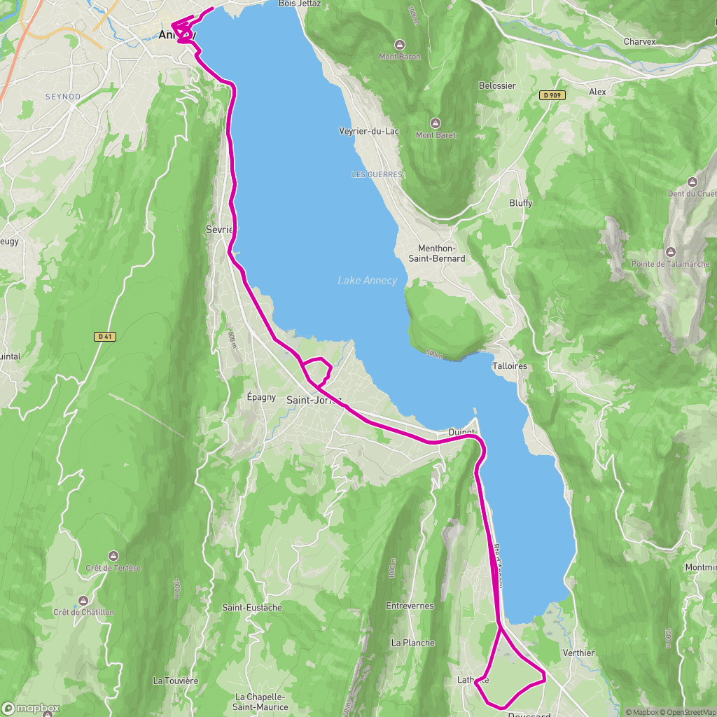
Routen brechen ChatGPT auf eine andere Weise. Du kannst ein Routenbild anhängen — etwa einen Strava-Screenshot — und um eine stilisierte Variante bitten. Das Modell greift die grobe Stimmung, aber die Polylinie bleibt nicht erhalten. Kurven werden gerade, Schleifen verschwinden, Start und Ziel verrutschen. GPX oder FIT als Geometriequelle hochzuladen geht nicht. Die Linie an der Wand ist also nicht die Linie, die du gelaufen bist.
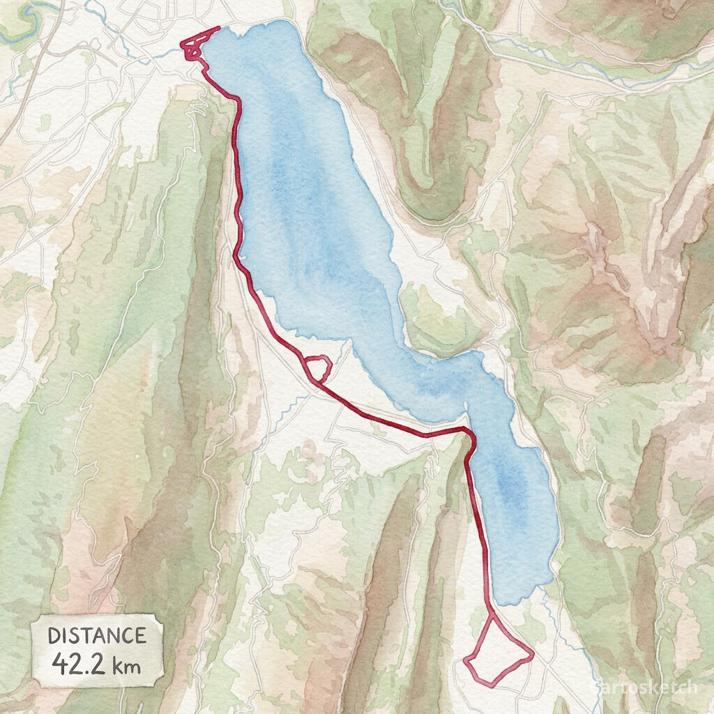
Cartosketch verarbeitet die GPX direkt. Der Browser parst die Datei, zeichnet die exakte Spur auf eine Mapbox-Leinwand, und genau diese Leinwand restyled die KI. Distanz, Höhenmeter und Zeit lassen sich in eine Statistikkarte einbrennen. Das Ergebnis hängt an der Wand als Aufzeichnung, nicht als Näherung.
Cartosketch handles the GPX directly. The browser parses the file, draws the exact track on a Mapbox canvas, and the AI restyles that canvas. Distance, elevation, and time can be burned into a stats card. The result hangs on the wall as a record, not an approximation.
 GPX on Mapbox
 Cartosketch
Dimension-by-dimension
5
Cartosketch wins
0
Tied
1
ChatGPT wins
| Feature | Cartosketch | ChatGPT |
|---|---|---|
| Geographic accuracy | ||
| GPS route support | ||
| Style variety | Limited | |
| Output resolution | Limited | |
| Print & commercial use | Limited | |
| Route stats overlay |
Geht es um einen echten Ort — deinen Block, dein Rennen, eine Ziellinie, einen Hochzeitsort —, dann Cartosketch. Soll sich das Bild nur wie diese Art von Ort anfühlen, dann ist ChatGPT schnell und unkompliziert. Die beiden beantworten unterschiedliche Fragen.
How Cartosketch does it
- For a place: open New Map, search the location, and frame it on Standard or Satellite.
- For a route: open New Route and drop in a GPX or FIT file (Strava, Garmin, or the official course).
- Pick a style — watercolor, comic, ink wash, ligne claire, blueprint, and more.
- Generate. The Mapbox capture locks in the geometry; the AI handles the look.
- Download up to 4K and print. Commercial use is included on every paid plan.
Frequently asked questions
- Can I just give ChatGPT a screenshot of the map?
- You can, and the result will be closer than a pure prompt. But the image model still rewrites the geometry rather than preserving it — streets shift and coastlines smooth out. Cartosketch treats the captured map as ground truth, so the layout is locked.
- Can ChatGPT read a GPX file?
- It can read GPX as text and summarise it, but the image side cannot use a GPX as a geometric base for the picture. Cartosketch's route flow parses the GPX and draws it on a real Mapbox canvas before any AI runs.
- Is Cartosketch better at art than ChatGPT?
- Cartosketch is not trying to be a general art tool. It is trying to be the best way to put a specific real place or route on the wall. For that one job, the geometry-first pipeline matters more than the size of the underlying model.
- Can I print and sell what I make?
- On Cartosketch, yes — commercial use is included on every paid plan, with the only caveat being not to reuse official names or logos as branding. ChatGPT's terms allow commercial use too, with their own caveats.
Neue Konten erhalten ein Gratis-Credit — keine Kreditkarte nötig. Product details