Cartosketch와 ChatGPT(GPT Image / DALL-E) 비교: 지도와 경로
ChatGPT는 한 줄 프롬프트로 '산토리니의 수채화 지도'를 그려 줍니다. 그런데 정말 산토리니를 그리고 있을까요? 지도 포스터와 GPS 경로 아트를 위한 실용적인 비교입니다.
이 글의 모든 이미지는 Cartosketch로 생성되었습니다 — 실제 Mapbox 지형과 GPS 경로를 재해석하는 AI 도구입니다.
ChatGPT는 가장 손쉽게 다가갈 수 있는 AI 이미지 도구입니다. 문장을 입력하면 이미지가 돌아옵니다. 대부분의 작업에는 그것만으로 충분합니다. 그러나 지도 아트와 GPS 경로 아트에는 잘못된 도구입니다. 모델이 약해서가 아니라 입력이 잘못되었기 때문입니다. 이 글은 ChatGPT(GPT Image / DALL-E)와 Cartosketch를 지도 아트에서 가장 중요한 두 가지 — 장소는 실제이고, 선은 당신의 것 — 를 두고 비교합니다.
ChatGPT가 강한 영역
ChatGPT의 강점은 대화의 쉬움입니다. 콘셉트를 다듬거나, 슬라이드용 일러스트 초안을 잡거나, 동화책의 장면을 스케치하거나, 로고 아이디어를 정리하는 일이 한 번의 한국어 대화 안에서 모두 이루어집니다. 이미지 모델은 구도 감각과 깔끔한 선이 좋고 시도당 비용도 낮습니다. 실제 장소와 일치할 필요 없는 일상적인 그래픽이라면 이 편안함을 이기기 어렵습니다.
지도에서 무너지는 지점
ChatGPT에 '산토리니의 수채화 지도, 위에서 본 시점'을 부탁하면 멋진 그리스 섬 이미지가 나옵니다. 초승달 모양과 칼데라가 있을 수도 있습니다. 그러나 그것은 산토리니가 아닙니다. 실제 섬은 특정한 윤곽선과 서쪽 절벽 위에 모인 마을 군집, 그리고 서쪽으로 떨어진 작은 부속 섬 티라시아를 가지고 있습니다. 모델은 그 어떤 것도 닻처럼 잡아 둘 수 없습니다. 시각적으로 특징이 분명한 유명 도시들 — 맨해튼 격자, 베네치아 운하, 파리의 에투알 광장 — 에서 환각이 가장 두드러집니다.
Cartosketch는 이 문제를 통째로 비켜갑니다. 산토리니의 실제 Mapbox 화면을 직접 잡고 — Standard 또는 Satellite, 원하는 줌과 피치로 — 그 화면이 기하학적 기반으로 모델에 전달됩니다. AI는 거기 있는 것을 다시 그릴 뿐, 해안선을 새로 만들지 않습니다.
 Mapbox
 Cartosketch
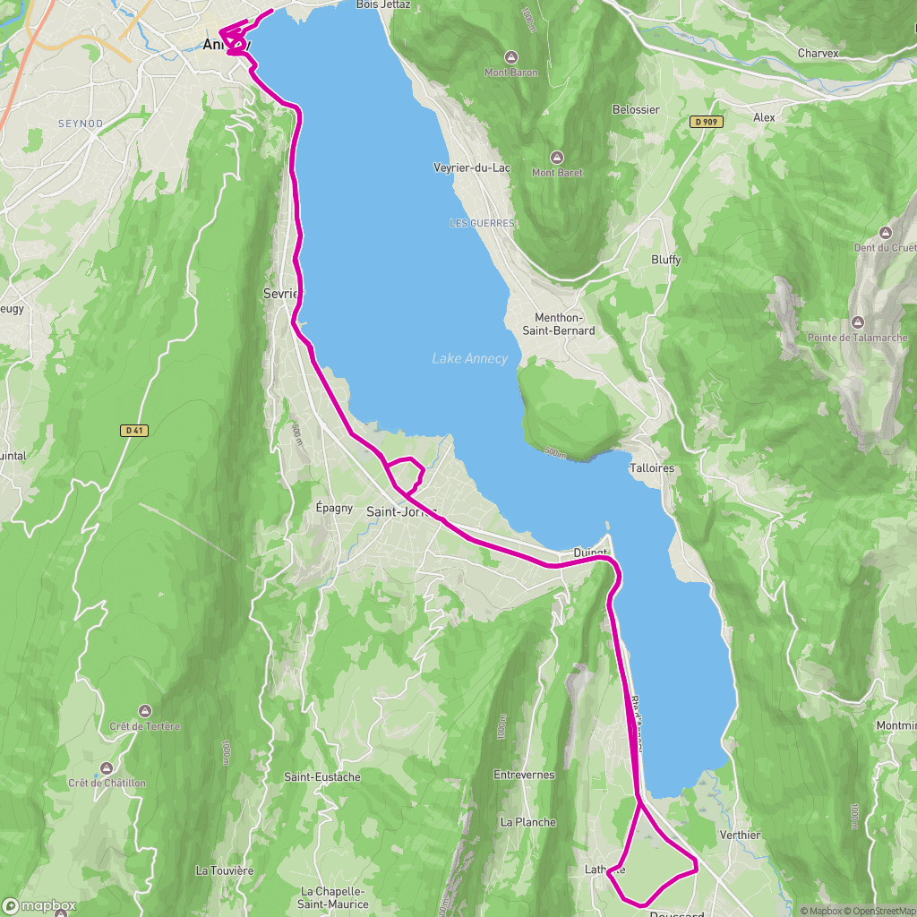
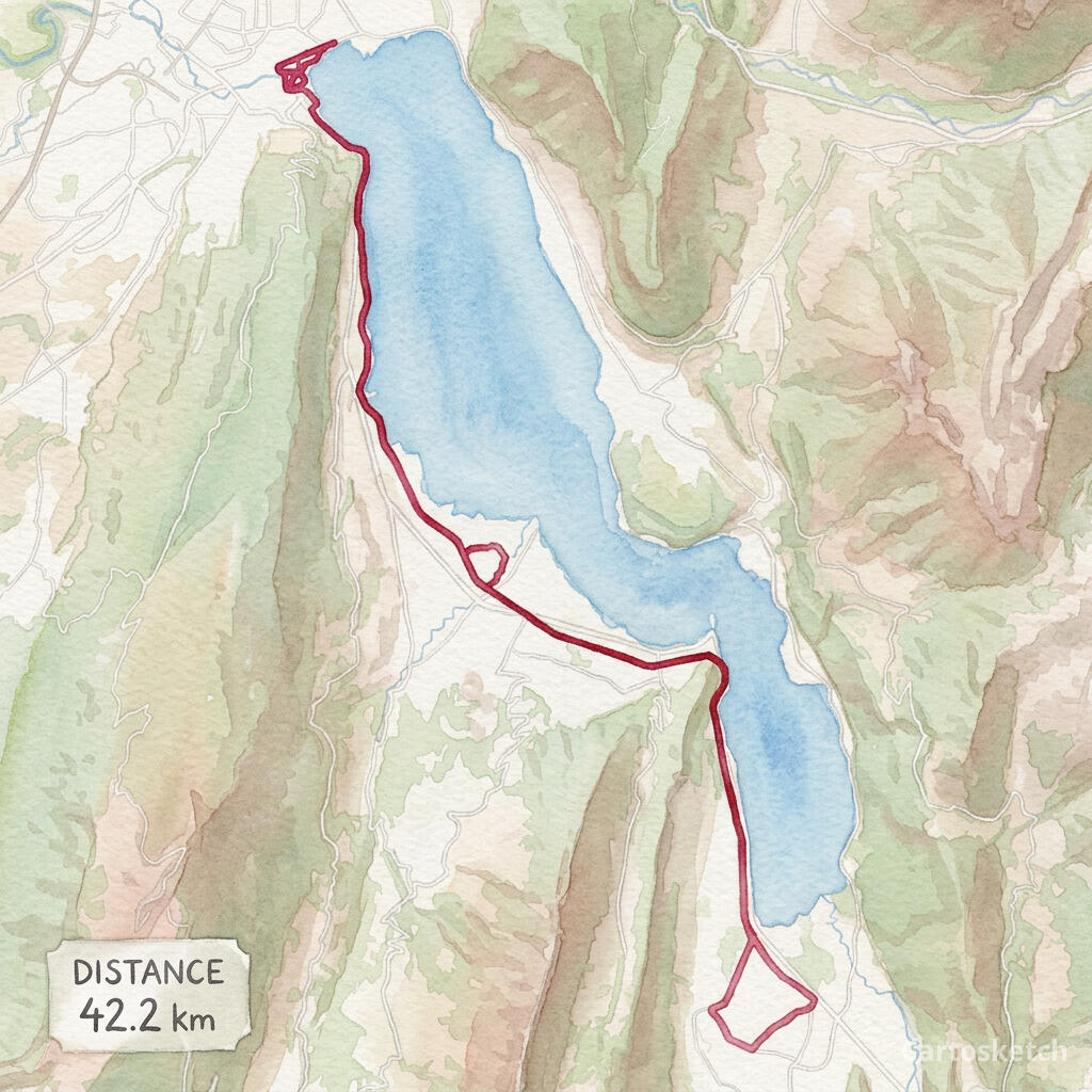
GPS 경로에서도 마찬가지
경로는 ChatGPT를 다른 방식으로 망가뜨립니다. 경로 이미지 — 예를 들면 Strava 스크린샷 — 를 첨부해 스타일화된 버전을 요청할 수는 있습니다. 모델은 전반적인 분위기는 잡아내지만 폴리라인은 보존하지 못합니다. 굽이는 곧게 펴지고, 루프는 사라지고, 출발과 결승이 흔들립니다. GPX나 FIT 파일을 기하학 소스로 올리는 기능은 없습니다. 결국 벽에 거는 선은 당신이 실제로 뛴 선이 아닙니다.
Cartosketch는 GPX를 직접 처리합니다. 브라우저가 파일을 해석해 Mapbox 캔버스 위에 정확한 트랙을 그리고, AI는 그 캔버스를 다시 그립니다. 거리, 고도, 시간은 통계 카드에 새길 수 있습니다. 결과물은 벽에 근사치가 아닌 기록으로 걸립니다.
Cartosketch handles the GPX directly. The browser parses the file, draws the exact track on a Mapbox canvas, and the AI restyles that canvas. Distance, elevation, and time can be burned into a stats card. The result hangs on the wall as a record, not an approximation.
 GPX on Mapbox
 Cartosketch
Dimension-by-dimension
5
Cartosketch wins
0
Tied
1
ChatGPT wins
| Feature | Cartosketch | ChatGPT |
|---|---|---|
| Geographic accuracy | ||
| GPS route support | ||
| Style variety | Limited | |
| Output resolution | Limited | |
| Print & commercial use | Limited | |
| Route stats overlay |
실제 장소의 그림이라면 — 당신의 블록, 당신의 레이스, 결승선, 결혼식 장소 — Cartosketch를 쓰세요. 그런 장소의 '느낌'만 필요하다면 ChatGPT가 빠르고 친절합니다. 두 도구는 서로 다른 질문에 답합니다.
How Cartosketch does it
- For a place: open New Map, search the location, and frame it on Standard or Satellite.
- For a route: open New Route and drop in a GPX or FIT file (Strava, Garmin, or the official course).
- Pick a style — watercolor, comic, ink wash, ligne claire, blueprint, and more.
- Generate. The Mapbox capture locks in the geometry; the AI handles the look.
- Download up to 4K and print. Commercial use is included on every paid plan.
Frequently asked questions
- Can I just give ChatGPT a screenshot of the map?
- You can, and the result will be closer than a pure prompt. But the image model still rewrites the geometry rather than preserving it — streets shift and coastlines smooth out. Cartosketch treats the captured map as ground truth, so the layout is locked.
- Can ChatGPT read a GPX file?
- It can read GPX as text and summarise it, but the image side cannot use a GPX as a geometric base for the picture. Cartosketch's route flow parses the GPX and draws it on a real Mapbox canvas before any AI runs.
- Is Cartosketch better at art than ChatGPT?
- Cartosketch is not trying to be a general art tool. It is trying to be the best way to put a specific real place or route on the wall. For that one job, the geometry-first pipeline matters more than the size of the underlying model.
- Can I print and sell what I make?
- On Cartosketch, yes — commercial use is included on every paid plan, with the only caveat being not to reuse official names or logos as branding. ChatGPT's terms allow commercial use too, with their own caveats.
신규 계정에는 무료 크레딧 1개가 제공됩니다 — 카드 등록 불필요. Product details