Cartosketch vs. ChatGPT (GPT Image / DALL-E) for Maps & Routes
ChatGPT can draw 'a watercolor map of Santorini' in one prompt — but does it actually draw Santorini? A practical comparison for map posters and GPS route art.
All artwork in this article was generated with Cartosketch — an AI tool that re-styles real Mapbox geography and GPS routes.
ChatGPT is the easiest AI image tool to reach. You type a sentence; an image comes back. For most jobs that is more than enough. For map art and GPS route art, it is the wrong instrument — not because the model is weak, but because the input is wrong. This post compares ChatGPT (GPT Image / DALL-E) and Cartosketch on the two things that matter for cartographic art: the place is real, and the line is yours.
Where ChatGPT wins
ChatGPT's strength is conversational ease. Iterating on a concept, drafting an illustration for a slide, sketching a children's book scene, or roughing out a logo idea — all of that happens in plain English in a single chat. The image model has a strong sense of composition and clean line work, and the cost per try is low. For everyday graphics that do not need to match a real place, that ease is hard to beat.
Where it falls apart on maps
Ask ChatGPT for "a watercolor top-down map of Santorini" and you will get a beautiful image of a Greek island. It might even have a crescent shape and a caldera. But it is not Santorini. The actual island has a specific outline, a specific cluster of villages on the west cliffs, and a small dependency called Thirasia off to the west — and the model has no way to anchor any of that. Famous, visually distinct cities (the Manhattan grid, the Venice canals, the Place de l'Étoile in Paris) are where the hallucination is most obvious.
Cartosketch sidesteps the whole problem. You frame the real Mapbox view of Santorini yourself — Standard or Satellite, the zoom and pitch you want — and that frame is sent to the model as the geometric base. The AI restyles what is there; it does not invent the coastline.
 Mapbox
 Cartosketch
That is the core comparison point in the real output: there is no visible watermark to distract you, but the geometry is still wrong. Building placements, landmark spacing, and the overall city layout drift away from the real map, which is exactly why Cartosketch treats the captured Mapbox view as ground truth.
And on GPS routes
Routes break ChatGPT in a different way. You can attach an image of a route — a Strava screenshot, say — and ask for a stylised version. The model can pick up the overall vibe, but it does not preserve the polyline. Bends straighten, loops disappear, the start and finish drift. There is no support for uploading a GPX or FIT file as the geometry source. So the line you put on the wall is not the line you actually ran.
Cartosketch handles the GPX directly. The browser parses the file, draws the exact track on a Mapbox canvas, and the AI restyles that canvas. Distance, elevation, and time can be burned into a stats card. The result hangs on the wall as a record, not an approximation.
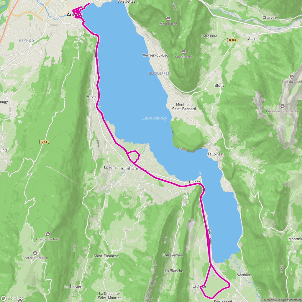 GPX on Mapbox
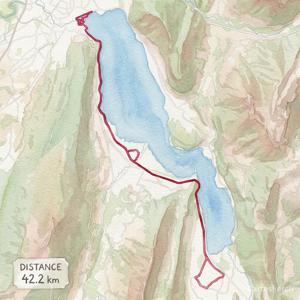 Cartosketch
Dimension-by-dimension
5
Cartosketch wins
0
Tied
1
ChatGPT wins
| Feature | Cartosketch | ChatGPT |
|---|---|---|
| Geographic accuracy | ||
| GPS route support | ||
| Style variety | Limited | |
| Output resolution | Limited | |
| Print & commercial use | Limited | |
| Route stats overlay |
When to use which
How Cartosketch does it
- For a place: open New Map, search the location, and frame it on Standard or Satellite.
- For a route: open New Route and drop in a GPX or FIT file (Strava, Garmin, or the official course).
- Pick a style — watercolor, comic, ink wash, ligne claire, blueprint, and more.
- Generate. The Mapbox capture locks in the geometry; the AI handles the look.
- Download up to 4K and print. Commercial use is included on every paid plan.
Frequently asked questions
- Can I just give ChatGPT a screenshot of the map?
- You can, and the result will be closer than a pure prompt. But the image model still rewrites the geometry rather than preserving it — streets shift and coastlines smooth out. Cartosketch treats the captured map as ground truth, so the layout is locked.
- Can ChatGPT read a GPX file?
- It can read GPX as text and summarise it, but the image side cannot use a GPX as a geometric base for the picture. Cartosketch's route flow parses the GPX and draws it on a real Mapbox canvas before any AI runs.
- Is Cartosketch better at art than ChatGPT?
- Cartosketch is not trying to be a general art tool. It is trying to be the best way to put a specific real place or route on the wall. For that one job, the geometry-first pipeline matters more than the size of the underlying model.
- Can I print and sell what I make?
- On Cartosketch, yes — commercial use is included on every paid plan, with the only caveat being not to reuse official names or logos as branding. ChatGPT's terms allow commercial use too, with their own caveats.
New accounts get one free credit — no credit card required. Product details